Cedar Crest Village
Cedar Crest Village
Cedar Crest Village
History of Cedar Crest Overlay
The Study Area
27 local property owners, representing 49 parcels, submitted a Village Overlay application for approximately 1000 acres in the Hoytsville area pursuant to the Eastern Summit County Development Code. The study area is loosely bounded by Interstate 80 on the west, Coalville on the north, Judd Lane on the south, and the Wasatch Mountains on the east.
The Committee
The Cedar Crest Overlay Committee is made up of community stakeholders and members of the Eastern Summit County Planning Commission. Committee members include: LaReen Judd, Melvin Brown, Mike Crittenden, Stefan Bowen, Mike Brown, Bill Wilde (Planning Commissioner), Tom Clyde (Planning Commissioner), Rich Sonntag (Planning Commissioner), Josh Sargent (alternate), Gary Siddoway (alternate).
Summit County Community Development Staff members provide technical expertise to support the work of the Committee. Staff that have worked on the project include: Patrick Putt (Community Development Director), Peter Barnes (Director of Planning, Zoning, and Design), Kirsten Whetstone (Planner), Sean Lewis (Planner), Sam Crittenden (Planning Intern), and Dave Parry (GIS).
The Committee and Development Staff, alongside Ivory Homes, have evaluated a variety of options for the Cedar Crest Village Overlay, all of which have led to the current land use plan being presented. The current plan has been designed to meet the vision of reestablishing and revitalizing existing, non-incorporated communities in Eastern Summit County.
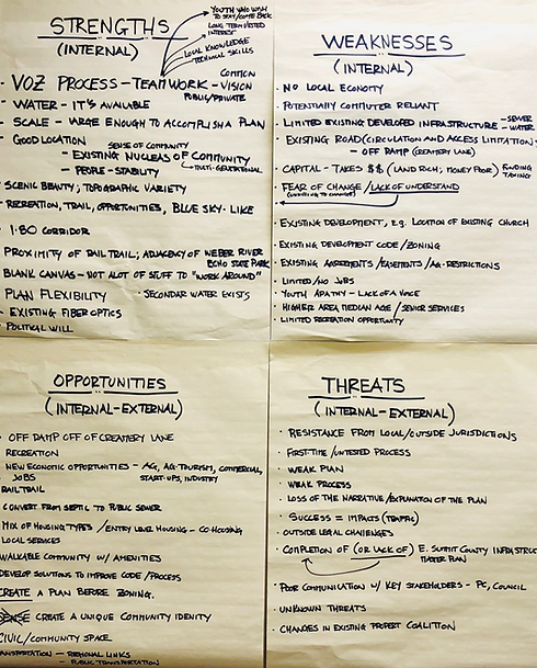
The SWOT Analysis (Strengths, Weaknesses, Opportunities, Threats)
Adopted by the Summit County Council in 2018, the Village Overlay is intended to incentivize cooperation and community design flexibility. The purpose of the Village Overlay is to reestablish and revitalize existing, non-incorporated communities in Eastern Summit County. The aim of the Village Overlay is to create a comprehensive, community-specific land use and design strategy to address community needs, including but not limited to:
- Construction of cost-efficient public and/or private infrastructure (streets, water, and wastewater).
- A range of housing opportunities.
- Space for local start-up businesses and live-work space.
- Local employment opportunities.
- Access to local shopping, eateries, offices, regional public transportation, service commercial and industrial uses, civic and institutional uses, etc.